Quick FactsOverview
About Gamma Hot Springs
Gamma Hot Springs, Washington is a free undeveloped geothermal spring in the Glacier Peak Wilderness, Snohomish County, reached by a multi-day backpack from the Suiattle River Trailhead near Darrington. The spring is not served by an official trail. Reaching it requires a long approach via the Suiattle River Trail (Trail 784), Pacific Crest Trail, and Gamma Ridge Trail (Trail 786), followed by off-trail descent into the Gamma Creek headwaters. Source temperature is approximately 140 degrees Fahrenheit, making it the hottest known spring in the North Cascades.
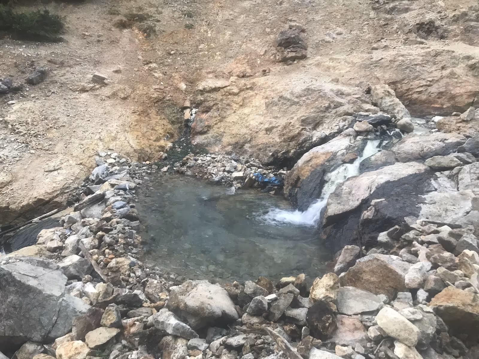
The soaking pool is small and natural, approximately 6 by 8 feet and capable of holding up to four people at a time. The pool sits close to Gamma Creek, which allows visitors to moderate the water temperature by mixing creek water with the hot spring flow. A black plastic tube near the spring is reported to contain a visitor log maintained informally by past backcountry travelers. The surrounding terrain is dense Cascade forest at high elevation on the northeast flank of Glacier Peak. No facilities of any kind exist at the spring and no signage marks the route or the pool itself. The spring is on public land within the Glacier Peak Wilderness and there is no fee to visit, though a Northwest Forest Pass may be required at the trailhead.
Location & Access
Getting to Gamma Hot Springs
Gamma Hot Springs is reached from the Suiattle River Trailhead, located at the end of Forest Service Road 26 (Suiattle River Road), approximately 23 miles from Darrington. From the trailhead, follow the Suiattle River Trail (Trail 784) for approximately 11 to 12 miles to the junction with the Pacific Crest Trail (PCT, Trail 2000). Continue on the PCT for a short distance to the junction with the Gamma Ridge Trail (Trail 786) heading east. Climb Gamma Ridge on Trail 786 until a safe descent route into the Gamma Creek headwaters can be identified. The final descent is off-trail, steep, and requires careful navigation. Total one-way distance from the trailhead to the spring is approximately 12 to 13 miles, with the off-trail section adding significant time and difficulty beyond the stated mileage.
The approach is typically done as a multi-day backpacking trip of at least two nights. Forest Service Road 26 (Suiattle River Road) has a documented history of washouts and may add additional hiking mileage before the formal trail begins. Always check current road and trail conditions with the Mount Baker-Snoqualmie National Forest Darrington Ranger District before departure. Trail washouts have been reported as recently as late 2025. For those seeking natural hot springs near Darrington Washington, Gamma is the most remote option in the North Cascades and requires experience, navigation tools, and full backcountry preparation.
Suitability & Accessibility
Suitability and Accessibility of Gamma Hot Springs
Gamma Hot Springs suits experienced backpackers who are specifically seeking a remote wilderness spring as part of a multi-day Glacier Peak Wilderness expedition. The approach is not suitable for day hikers, casual visitors, or anyone without solid backcountry navigation skills. The off-trail section near Gamma Creek requires the ability to route-find on steep, brushy, and potentially snow-covered terrain using a topographic map, compass, and GPS device. A detailed topo map covering the Gamma Peak quadrangle and the Green Trails Glacier Peak sheet is essential preparation.
The spring pool itself is tiny. At approximately 6 by 8 feet, it holds up to four people and is by nature a quiet, solitary experience. Wait times may occur if another party arrives first. The water temperature near the source vent is dangerously hot and only the areas where spring flow mixes with Gamma Creek are suitable for soaking. There are no facilities, no developed campsites at the spring, and no cell coverage in the area. Wildlife including bears are present throughout the Glacier Peak Wilderness. Food must be stored in a bear canister or hung using proper backcountry technique.
Gamma Hot Springs is not wheelchair accessible and is not suitable for families with children or visitors without extensive backcountry experience. For those seeking natural hot springs near Darrington Washington, Baker Hot Springs in Mount Baker-Snoqualmie National Forest offers a far more accessible undeveloped alternative for the same region.
Safety & Etiquette
Gamma Hot Springs Safety Tips
Gamma Hot Springs is a remote area natural hazard environment with no staff, rangers, or services. The spring source temperature of approximately 140 degrees Fahrenheit is well above the safe soaking limit of 104 degrees. Only areas where the hot spring mixes with Gamma Creek water are suitable for soaking. Test the temperature carefully before entering and never sit near the source vent. Redirecting creek flow into the pool is the standard method to moderate temperature.
Forest Service Road 26 and the Suiattle River Trail have both experienced serious damage from storms and washouts in past years. Check current road and trail status with the Darrington Ranger District before departure. Carry a paper topo map and GPS with offline maps. Do not rely on cell signal. Allow extra days in your plan for weather delays, route-finding difficulties, and possible trail blockages.
Wilderness permit requirements for the Glacier Peak Wilderness may apply depending on group size and season. A Northwest Forest Pass or equivalent is typically required at the Suiattle River Trailhead. Stream crossings on the approach trail can be dangerous during spring snowmelt and after heavy rain. Assess water levels before committing to any crossing.
The terrain from Gamma Ridge into Gamma Creek drainage is steep and can be snow-covered well into summer. An ice axe and microspikes should be considered depending on season. The final descent involves loose rock, wet vegetation, and no clear path. Do not continue if the descent looks beyond your skill level. Plan your turnaround time to allow a safe return to the trailhead before dark.