
Quick FactsOverview
About Sykes Hot Springs
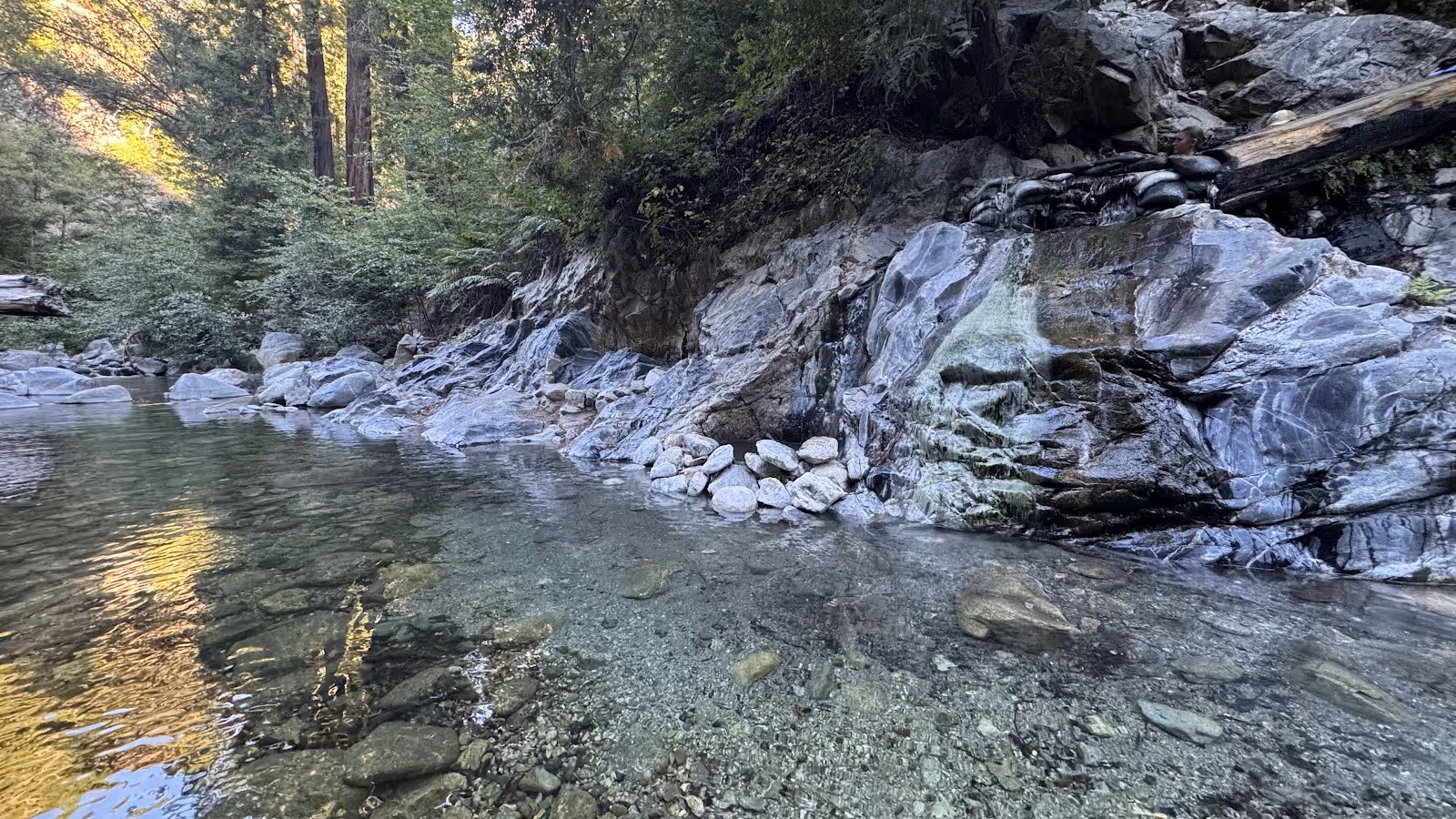
Sykes Hot Springs, California is a backcountry hot spring in the Ventana Wilderness of Los Padres National Forest, reached by the Pine Ridge Trail from Big Sur Station on Highway 1. The springs sit beside the Big Sur River at approximately 1,080 feet elevation, roughly 9 to 10 miles by trail from the trailhead. Two to three natural rock-lined pools are heated by geothermal activity to around 100 degrees Fahrenheit, varying by season and water flow conditions.
The springs are the only natural hot springs on the California coast outside a fenced resort, and they occupy a distinct place in California outdoor culture. They were closed from 2016 to April 2021 following the Soberanes Fire, one of the most destructive fires in Big Sur history, which damaged the trail corridor significantly. Since reopening, sections of the Pine Ridge Trail have been rerouted due to slides and washouts; current trail conditions should be verified before departure.
For visitors seeking free natural hot springs in California that combine a true wilderness backpacking experience with coastal redwood forest and river canyon scenery, Sykes is among the most compelling destinations in the state. The journey along the Big Sur River corridor is as much a part of the experience as the soak itself.
Location & Access
Getting to Sykes Hot Springs
Sykes Hot Springs is reached via the Pine Ridge Trail starting at Big Sur Station, located on Highway 1 approximately 26 miles south of Carmel and 30 miles south of Monterey. The trailhead is clearly marked at Big Sur Station, where parking costs $10 per day payable at an iron ranger or at the station window. A self-issue wilderness permit is available at the trailhead kiosk and must be completed before entering the wilderness.
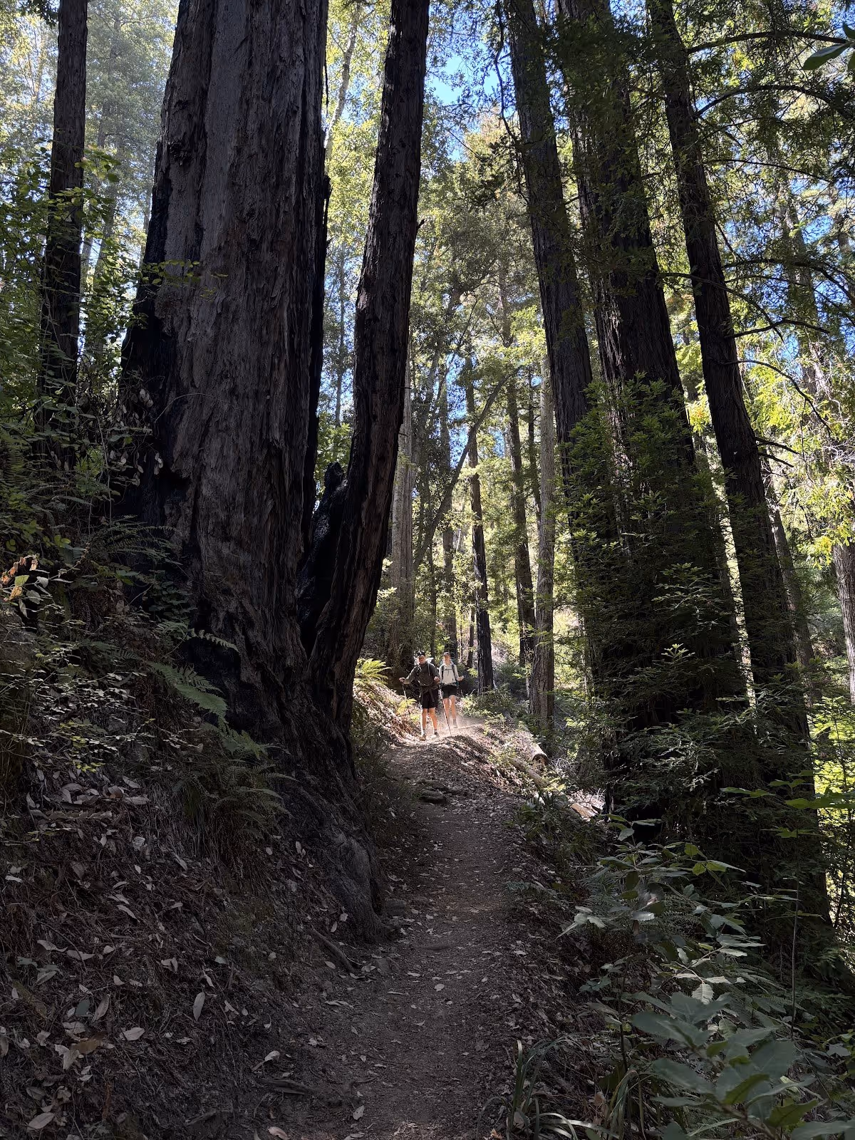
The Pine Ridge Trail is 9 to 10 miles one way with approximately 5,442 feet of cumulative elevation gain, making it a demanding full-day hike or, more practically, an overnight backpacking trip. The trail passes through coastal redwood groves, open ridgelines, and the Big Sur River canyon before reaching Sykes Camp and the springs. Multiple river crossings are required; in winter and after heavy rain these crossings can be impassable or dangerous. Current trail conditions, reroutes, and crossing status should be checked with the Ventana Wilderness Alliance before departure.
Cell service is absent for most of the trail and entirely absent at the springs. Offline maps should be downloaded before leaving the trailhead. For those researching hot springs near Monterey deep in the coastal backcountry, Sykes is the defining destination in the region, drawing hikers from across California and beyond.
Suitability & Accessibility
Who Sykes Hot Springs Suits
Sykes Hot Springs suits experienced backpackers and strong hikers who are comfortable with a strenuous multi-day wilderness trip, multiple river crossings, and a remote environment with no services. The 9 to 10 mile one-way hike with over 5,000 feet of cumulative elevation gain is not appropriate for casual day hikers, beginners, or families with young children. Most visitors treat this as a two- to three-day backpacking trip rather than a day hike.
The site is not wheelchair accessible. The Pine Ridge Trail has significant elevation changes, uneven terrain, and river crossings that make it inaccessible to anyone with mobility limitations. No infrastructure exists at the springs beyond the natural pools and the adjacent Sykes Camp.
Clothing is optional at the springs, consistent with the remote, self-regulating character of the Ventana Wilderness. Dogs are permitted on the trail on a leash, though the distance and demanding terrain make bringing a dog a significant undertaking that requires careful planning. Camping at Sykes Camp, which has seven first-come sites adjacent to the springs, is the standard approach for visitors wanting more than a brief soak; most backpackers plan for two nights to allow a full day at the springs before hiking out. The trail also passes Willett Hot Springs at roughly 9 miles from the trailhead via the Sespe River route, which some hikers visit as an intermediate stop.
Safety & Etiquette
Safety at Sykes Hot Springs
Sykes Hot Springs presents serious backcountry conditions that require thorough preparation. The most significant hazard is the Big Sur River itself: multiple crossings are required to reach the springs, and winter or post-storm flows can make crossings impassable or life-threatening. The Ventana Wilderness Alliance explicitly warns that winter crossings can be impossible due to high water and dangerous flow. Checking current crossing conditions before departure is essential.
The trail involves substantial elevation gain and loss over nearly 20 miles round trip. Heat, exhaustion, and dehydration are real risks, particularly in summer when the exposed ridgeline sections receive direct sun. Starting the hike early, carrying more water than expected, and building a conservative turnaround time into the plan are all practical necessities.
Bear canisters are strongly recommended in the Santa Lucia Mountains. Human-bear interactions are rare but the food storage practice matters. Campfire restrictions are in place most of the year, even when a permit has been issued; stove permits are required for all cooking. Current fire restrictions should be confirmed at the trailhead. Poison oak is present along the lower trail sections and river corridor.
A $10 parking fee is paid at Big Sur Station. A self-issue wilderness permit is required at the trailhead and is free. Highway 1 in Big Sur can close with storm damage; road status should be checked before traveling, particularly in winter. The Ventana Wilderness Alliance website is the most reliable source for current trail and crossing conditions.